Mago National Park

Mago National Park is in South Omo Zone, 35km south-west of Jinka, the administrative centre of the Zone.
The Mago River flows through the centre of the park and joins the Neri River at Mago swamp, before continuing southwards as the Usno to join the Omo River. The river, which is 760 km long, originates in the central, south-western highlands of Ethiopia, where it is known as the Gibe. Its final destination is Lake Turkana, close to the Kenyan border.
Proclaimed in the 1960, the 2,162 km2 Mago National park is bisected by the Mago Rivers which flow into the Omo in the park’s southern boundary. Although Mago National Park share some 5km of its southwestern boundary with Omo National Park, the protected areas effectively form one ecological unit.
The altitude at the edge of the park is 400 m. To the east are the Mursi Hills, rising to over 1,600 m. North of the Neri river are the Mago mountains with the highest point, Mt Mago, at 2,528 m. The south-eastern quarter of the park is crossed by many small streams and rivers. The headquarters for the park are by the Neri River, near the entrance from Jinka.
The main habitats of the park and surrounding area are the rivers and riverine forest, the wetlands of Mago swamp and Lake Dipa, the bush land, savanna grassland and open grassland on the more level areas, and bush land and scrub on the sides of the hills. Open grassland comprises just 9% of the area, the rest of the area being described as very dense. The largest trees are found in the riverine forest beside the Omo, Mago and Neri. Areas along the lower Omo (within the park) are populated with a rich diversity of ethnic groups including the Ari, Banna, Bongoso, Hamer, Karo, Kwegu, Male and Mursi peoples. A number of these groups live beside the river and make extensive use of its natural resources and its levees to grow crops.

Gambella National Park

Gambella National Park is a remote and swampy park established primary to protect population of two endangered wetland antelopes whose range is restricted to this part of Ethiopia and adjacent regions in southern Sudan. The park has never been fully protected, the area does support significant though shrinking populations of Elephant, Buffalo and Lion, as well as Roan antelope, Tiang, Lelwel hartebeest, Olive baboon and Guereza monkey. Several interesting birds inhabit the Gambella National Park, notably Ethiopia’s’ only population of the elusive and weird looking Shoebill Stork. Other interesting and unusual species found in the park include the country’s entire population of the localized Lelwel hartebeest, Paradise Whydah, the lovely Little green bee eaters, as well as Black-faced Fire Finch, Red-necked Buzzard, Egyptian Plover, and several localized but drab Cisticolas and other Warblers.

Bale Mountains National Park

Bale Mountains National Park: This is a magnificent high altitude plateau with numerous dramatic volcanic plugs, seasonal tiny alpine lakes and cascading mountain streams. Located at about 400 kilometres from Addis Ababa, it is stretched over an area of 2000 square. kilometress with in altitude ranges of 1500m-4377m above sea level. Being the largest Afro Alpine habitat park in Africa, Balé mountain National Park offers the following major features of attraction.
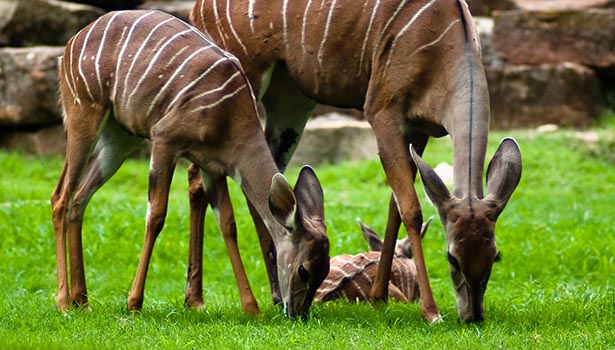
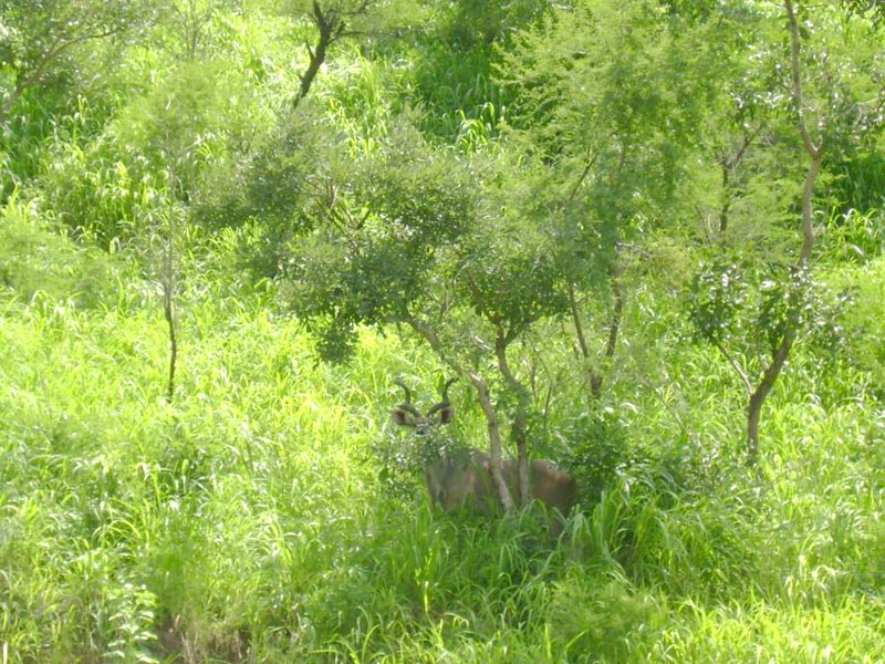
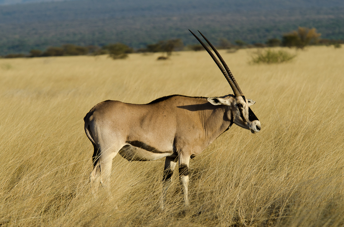
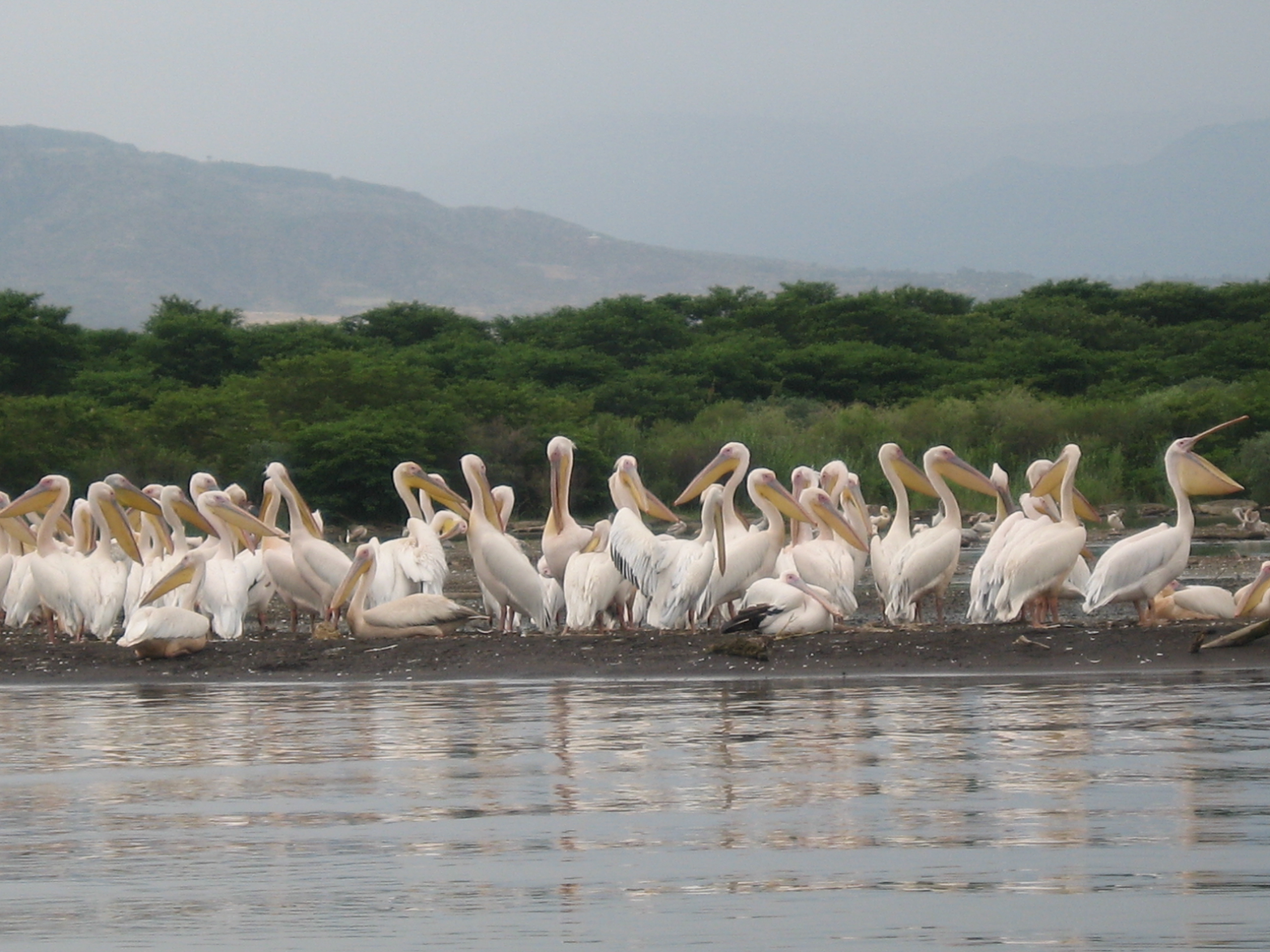
It gives chances of viewing about 46 mammal and more than 200 bird species and vegetation of unspoiled wonderland including various tree species and precious endemic mammals, namely Red Fox, Mountain Nyala, and Menelik’s Bushbuck.
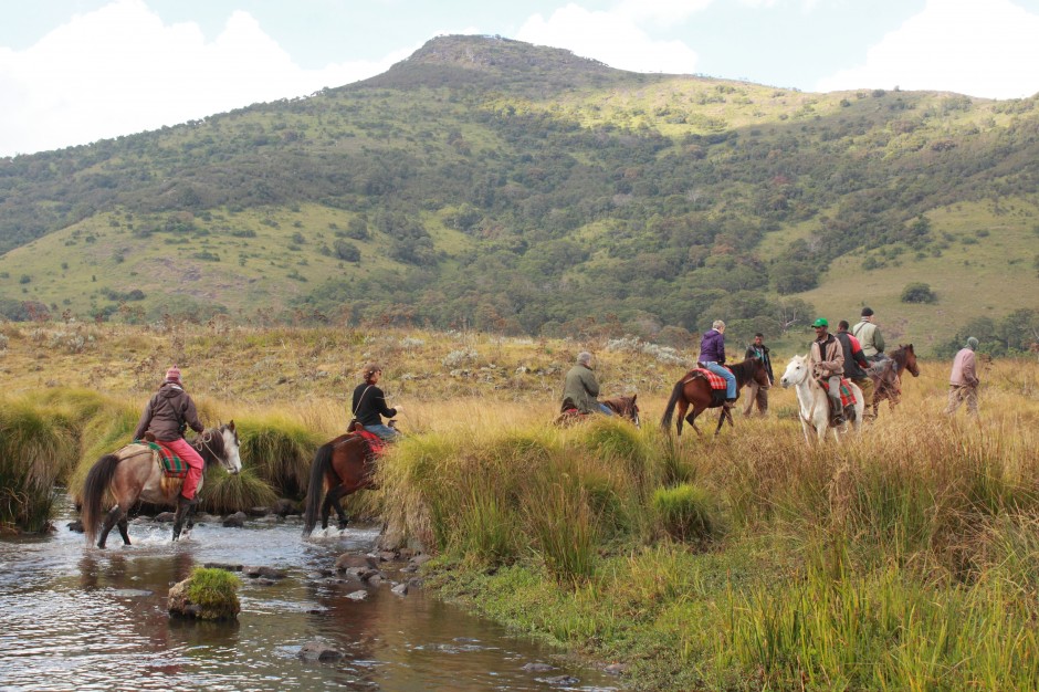
Its climate is mostly very cold with high rainfall and damp cloud with rare sparkling blue sky. The best season of walking, trekking and camping in the park to view the endemic life and enjoy other tourist activities in the astonishing vast alpine areas is the dry season which is from November to March. Visitors can also enjoy the habitat at all seasons with warm and weather proof clothing.
The three main divisions of the park, includes the northern area-Dinsho and Gassay Plain the central alpine part-Sanaté, and the southern forest area-Haranna that offer distinct features. Dinsho area is the perfect site of viewing Mountain Nyala and Menelik’s Bushbuck, etc. Tourists can also visit the head quarter and the museum of the park here at Dinsho and get lodge service and relevant information about the park.
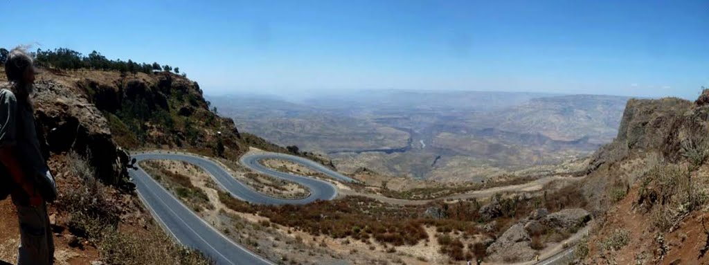
Sanaté, nick-named as “ The Island in the Air”, is a high plateau souring up over 4000m on top. The second highest peak next to Ras Dashen in Ethiopia, Tullu Dimtu (4377m above seal level), is among many peaks on the plateau found. An all weather road from Goba to Dallo Manna passes over this plateau. The seasonal tiny alpine lakes, some rare birds, and above all, the endemic Red Fox, and giant Molrat the top tourist attraction mostly specific to Balé Mountains National Park are spotted here.
The southern Haranna area is an area of lower altitude covered with dense moist tropical forest. The road penetrating Sannaté and Haranna forest connects Goba with Dallo Manna. Bush pig, a frican hunting dog, giant forest hog, spotted hyena, lion, leopards, colobus monkey, etc. abound in Haranna forest area.
The beautiful rainbow and trout fish stocked in the park rivers with fry from Kenya in 1960 may give tourists a fishing opportunity if they have time.
The lodge at Dinsho provides tourists with 31 beds (room 6) and kitchen equipment for self service. The accommodation is simple but pleasant. Camping at Dinsho and at different sites in the park gives great delight to tourists. The Bekelé Mola (at Robé) and the Wabé Shebelé (at Gobba) Hotels welcome tourists with accommodation and catering services.
While in Bale Mountains National Park there are important specific sites worth visiting, these are Dinsho head quarter site, Gassay Valley, sannate- Tullu Dimtu, Harana escarpment, Harana forest-Kacha site Weib valley and others.

Touristic Appeal: The Bale Mountains National Park is an area of major importance in nature conservation, scientific research, education and tourism. Among the major factors that contribute to its tourist appeal, the following distinctive feature can be mentioned:

  • The park conserves the largest area of afro alpine habitat on the continent of Africa;
  • The Harana Forest, at the south of the area, is the second largest stand of moist tropical forest remaining in Ethiopia;
  • The area is a centre of endemicity that conserves stocks of genetic materials, much of which is not just endemic to Ethiopia, but is confined only to these mountains;
  • The area contains the largest population of endemic Mountain Nyala and the endangered Red Fox.
  • The area also contains the entire global population of giant molerat etc.

Awash National Park

Awash National Park: stretched over 756 kilometres2 AWNP is situated at 225 kilometress south east of Addis on the plain through which the highway and railway line leading to Dire Dawa and Djibuti passes.
Establish in 1966, Awash National Park is the first officially gazetted wildlife reserve in the country. The park is entirely established on the plain of the Rift Valley. With the exception of 2600m high mountain Fantallé, the park area is predominantly covered with shrub, bush, acacia and open grass lands.

The main tourist attractions of the park include:

  • The 46 major species of mammals and 453 species of birds among which six species are endemic to the country. All the mammals are East African plain animals origin like greater and lesser Kudus, oryx, bush buck, dik-dik, gazzelle, fox, klipspringer, cheetah, lions and others. The bird species include secretary birds, Abyssinian ground hornbill, carmine bee eater, Abyssinian Roller and birds of riverine forest like coucal, turaco and goaway birds;
  • The Awash River that at the end of its gentle flowing course in relatively plain surface, suddenly drops into a gorge where the waters hit the bottom basaltic rocks to form a smoky water falls offering delightful sensation;
  • Fantallé mountain, which rises majestically over the surrounding low land with its fascinating feature of volcanic origin, and depression on the top of the mountain that form a rugged surface with clouds of volcanic steam rising here and there;
  • The palm springs of the northern part of the park, where hot water springs from the wall of hill flows down making a stream and a natural swimming pool amidst palm trees;
  • The museum in the park head quarters where trophies of animals living in the park are displayed;
  • The 22 caravans stationed on the edge of the Awash river gorge and the camp sites along the gently flowing Awash river where visitors could camp under riverine trees give opportunity to see crocodiles in the river and other larger animals that come to drink water.

Abijata-Shalla National Park

At about 215 kilometress from Addis Ababa, visitors will arrive at Abijata-Shala National Park main gate or “Lakes Park” which was once reputed as one of the bird watchers ground in Africa. It was 887 square.kilometress in area out of which 482 square.kilometress is covered by water of Lake Abijata and Shala. This park used to have about 31 species of mammals such as Spotted Hyena, Golden and Black Backed Jakals, Olive Baboon, Grant’s Gazelle, etc., and 367 species of birds. But currently due to devastated ecology and extreme decrease of Abijata Lake water, one can see only less concentration of flamingoes.
Before, myriad of local and exotic birds that come from Europe and different parts of the world used to congregate here in at Lake Abijata. July to September being the peak season of congregation (and best time to watch birds) in the year. Hundreds of thousands of Flamingoes and Great White Pelicans, Fish Eagles, King Fishers, the tall Marabou Stork, Cormorants and Darters, etc. used to roam here in Lake Abijata and in the side-by lake Shala. There were also vast colonies of sacred Ibis, Queela, Stilt, Snope Black Heron, Avocet, Egyptian Geeze, Eglets, Plovers, etc. It is quite unlikely however, to see most of the birds mentioned above while some species are seen in small number (seasonally), due to the same reason stated earlier.
Located at 215 kilometres from Addis Ababa the small enclosure varicocele hcg of Ostrich farm hosts a group of ostriches with some Grant’s Gazelles. At the park’s head quarter one can easily observe (watch) a flock of male and female ostriches and some gazelles. Lake Shala, which is separated to the south from lake Abijata by a strip of land has a delightful view for its deep blue color with excellent reflections of the magnificent western hills. At the north eastern shore of the lake Shala, one can be impressed by a tumbling cascade of hot springs and smoke of vapor that rush out down to the bay. This is typical investment potential for spa resort development and some investors are being attracted by this intact nature.
The other fascinating part of the lake is the Gike Site. It is situated on the lofty land at the south western shore of lake Shala. This is the best site for bird watching and camping. It is accessible by a sturdy car through Aware and Senbete towns found south of Shashamane. Lake Shala is also the ideal lake for water transportation to make touring around the tiny islands and for connecting its western and eastern shore.
South west of lake Shala, there is also a small alkaline crater lake known as lake Chittu. This small lake, more than any other lake, is the best site of bird watching, especially the flamingoes. Chittu is accessible by four wheel drive via Sambaté town.

Tiya steale

Tiya is a megalithic site located at about 80km south of Addis Ababa in Soddo area on the road to Butajira. The monuments are supposed to be remains of medieval Ethiopia culture apparently dated from the 12th to 14th centuries. However, the local people claimed that they were the grave marker of the soldiers of Ahmed Gragn, dating the site to the 16th century.
The Tiya monuments belong to one of stone 160 megalithic sites in the Soddo region. There are more than 45 standing monuments in Tiya. Few of them were removed from the site and can be seen in the main campus of Addis Ababa University 6kilo, erected near the Institute of Ethiopian Studies (IES). Most of Tiya monuments measure a height between a meter and 3 meter though the largest one is about five meters, including its section underground. The Tiya grave-markers are decorated with carvings of various representations. The meanings of the symbolic decorations are still open to speculation for various scholars. The major carved designs of the monuments are the swords, a kind of plants or carvings of leaves below the sword, carved circles, a carving like the letter ‘M’ on its side and the carving like the letter ‘X’ with slightly carved lines. Different scholars give different meanings for the carved

Sof Omar Caves

Sof Omar, a tiny Muslim village in Bale, is the site of an amazing complex of natural caves, cut by the Weyb River as it found its way into the nearby mountains. The settlement, which is a religious site, is named after a local Sheikh.
There one can see an extraordinary number of arched portals, high, eroded ceilings and deep, echoing chambers.

Lake Tana

Lake Tana, the largest lake, in Ethiopia is the source and from where the famed Blue Nile starts its long journey to Khartoum, and on to the Mediterranean. The 37 islands that are scattered about the surface of the lake shelter fascinating churches and monasteries, some of which have histories dating back to the 13th century. However, it should be noted that most of the religious houses are not open to women. The most interesting islands are: Birgida Mariam, Dega Estephanos , Dek, Narga, Tana Cherkos, Mitsele Fasiledes, Kebran and Deber Maryam.

Danakil depression

The Danakil Depression, also called Dallol Depression, is a desert with some areas that are more than 100 meters below sea level. This is special because it is one of the lowest points on 10625052_336086799896785_7362590314756292688_n
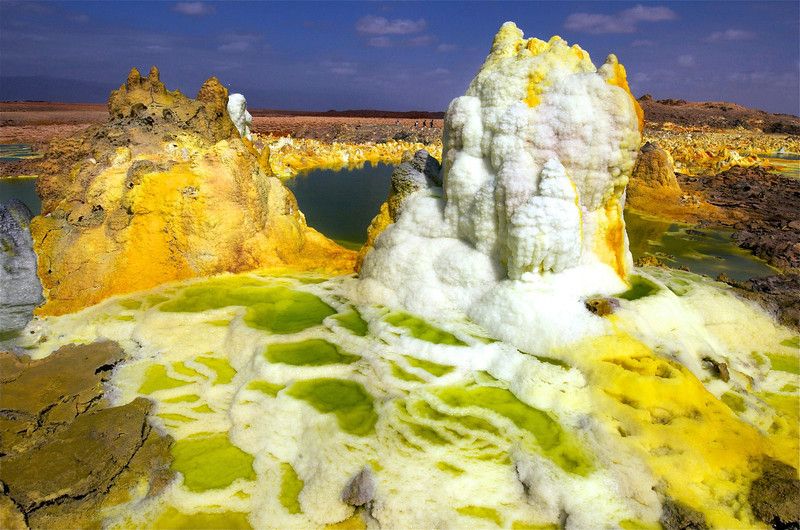
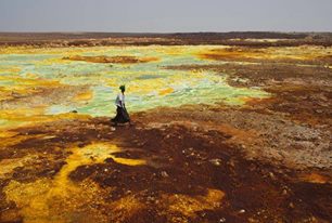
earth not covered by water. There are hot yellow sulfur fields among the sparkling white salt beds. Heat isn’t the only thing people feel in the Dallol Depression. Alarming earth tremors are frequently felt. There are also several active volcanoes. So just how hot is it at the Dallol Depression.

The landscape is dotted with bright yellow sulphur fields, green crystal pools and sparkling salt beds. This is the Danakil Depression, a basin in north-eastern Ethiopia, close to the Red Sea. It is one of the lowest points on earth not covered by water. Danakil is renowned for being the place with the highest average temperature on Earth. It tops 34 °C every day of the year and soars to 55 °C in the summer. Temperatures can reach as high as 63 °C in the sun.

The people who are living in the region are Afar tribes, they are pastoralists and some of them 11889464_468834896621974_1208690523341440302_n
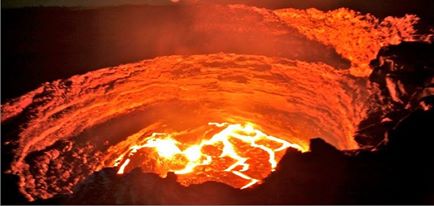
engaged in salt mining as the depression is covered with salt.
The most attraction in the region is Ertale, Active volcano, which is so magnificent attraction due to its different colorful lava flowing from the crust of the earth.

Blue Nile Gorge

Within 30 km of its source at Lake Tana, the Blue Nile River enters a canyon which it does not leave for 400 km. From all over the highlands, huge rivers pour into the Blue Nile Gorge. For a million years the Blue Nile has been carving this huge gash through the Ethiopian Highlands. Nearly 20km wide and over 600km long, this is Africa’s own Grand Canyon. The Grand Canyon in Arizona, U.S.A. and the Blue Nile Gorge have their similarities and differences.